|
Ille-et-Vilaine is a part of the current region of Brittany and is bordered by the departments of Manche to the north-east, Mayenne to the east, Maine-et-Loire to the south-east, Loire-Atlantique to the south, Morbihan to the south-west, and Côtes-d'Armor to the west and north-west. Also the English Channel (la Manche in French) borders the department to the north.Ille-et-Vilaine is a part of the current region of Brittany and is bordered by the departments of Manche to the north-east, Mayenne to the east, Maine-et-Loire to the south-east, Loire-Atlantique to the south, Morbihan to the south-west, and Côtes-d'Armor to the west and north-west. Also the English Channel (la Manche in French) borders the department to the north.
The department is named after its two main rivers, the Ille and the Vilaine, whose confluence is in Rennes, the capital of the department and of the region. Other important rivers include:
the Rance, that borders the department in the north-west and flows to the north, creating a deep fjord before reaching the English Channel on the western part of the coast (named Côte d’Émeraude) between the cities of Dinard and Saint-Malo); the Rance river is connected from the west of the department to the Ille river in the north-west suburbs of Rennes with a navigable channel (then the Ille river is channelized to join the Vilaine up to the center of the city of Rennes);and the Couesnon that borders the eastern part of the department and which reaches the eastern part of the coast of the English Channel, in the flat Bay of the Mont Saint-Michel.The department is moderately elevated above the level of the sea, with many hills; however the central part has a dense network of many tributaries to the Ille or the Vilaine from all around the large basin of Rennes. The elevated hills bordering this basin are covered by several old forests now exploited by men for the production of wood. The basin itself is a rich agriculture area, as well as the north-west of the department near the Rance.
In the extreme south of the department the Vilaine goes through a slower decrease in elevation in a small corridor in the area of the city of Redon; in this area, the Vilaine is known for its frequent floods during its recent history, often because of too-intensive draining of agricultural areas around Rennes (some floods also affected some parts of Rennes up to the 1980s due to incorrect management of old equipment of the canal of Ille-et-Rance). To avoid these hazards within inhabited cities, some natural fields bordering the Vilaine in the south of the department are now left floodable, and works for regulating the level have been done including, small artificial lakes with derivation channels, replanting trees in the basin, better management of forests, and regulating the artificial drains made for agriculture.
In 2016 it had a population of 1,052,000 living in 6,775 km2
This information from https://en.wikipedia.org/wiki/Morbihan
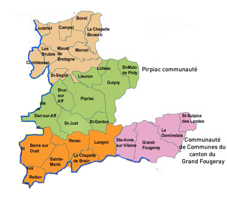
The Map to the right shows those communes which with parts of Morbihan and Loire Atlantique make up Pays De Redon and services provided by Redon Agglomeration.
For photographs of the communes select from the drop down menu above.
|
Flag by CC BY-SA 3.0, https://commons.wikimedia.org/w/index.php?curid=584635
|